
| Weather Data | |||
|---|---|---|---|
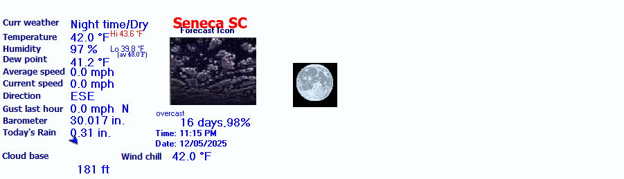
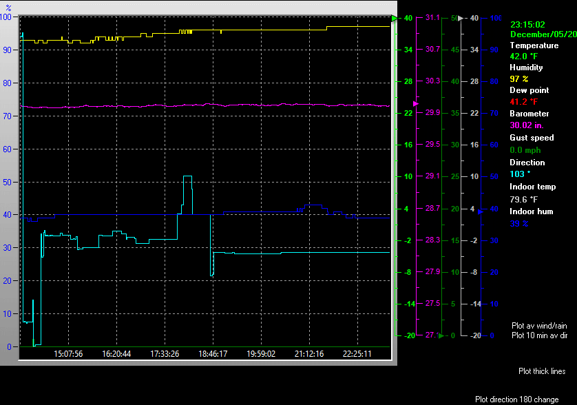
| LAST READING AT TIME: 9:55 PM DATE: December 05 2025, time of next update: 10:00 pm | |||
| Current Weather | Night time/Dry | Current Temperature | 41.9°F (5.5°C), Apparent temp 40.6°F |
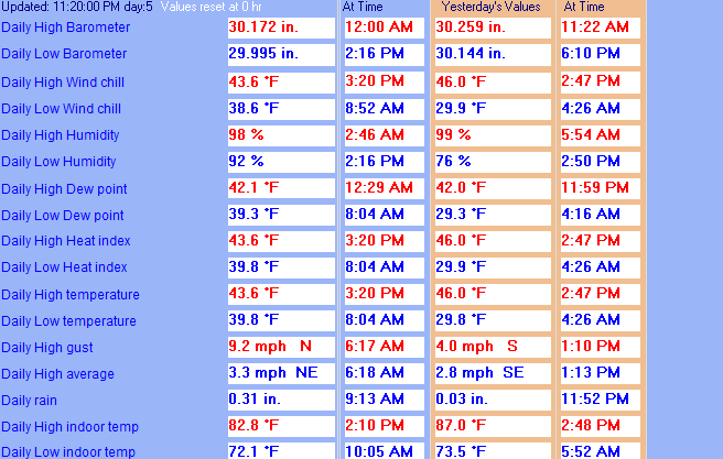
| Maximum Temperature (since midnight) | 43.6°F at: 3:20 PM | Minimum Temperature (since midnight) | 39.8°F at: 8:04 AM |
| Average windspeed (ten minute) | 0.0 mph | Wind Direction (ten minute) | ESE (112°) |
| Windchill Temperature | 41.9°F | Maximum Gust (last hour) | 0.0 mph at: 9:00 PM |
| Maximum Gust (since midnight) | 9.2 mph at: 6:17 AM | Maximum 1 minute average (since midnight) | 3.3 mph at: 6:18 AM |
| Rainfall (last hour) | 0.00 in. (0.0 mm) | Rainfall (since midnight) | 0.31 in. (7.9 mm) at 9:13 AM |
| Rainfall This month | 1.44 in. (36.6 mm) | Rainfall To date this year | 1.92 in. (48.8 mm) |
| Maximum rain per minute (last hour) | 0.00 in/min | Maximum rain per hour (last 6 hours) | 0.00 in/hour |
| Yesterdays rainfall | 0.03 in | DewPoint | 41.1°F (Wet Bulb :41.6°F ) |
| Humidity | 97 %, Humidex 40.7°F | Barometer corrected to msl | 30.028 in. (1016.9 hPa) |
| Pressure change | -0.01 in. (last hour) | Trend (last hour) | STEADY |
| Pressure change (last 12 hours) | -0.09 in | Pressure change (last 6 hours) | +0.01 in |
| Current Indoor Temp. 81.4°F | |||
| Current Indoor Hum. 41% | |||
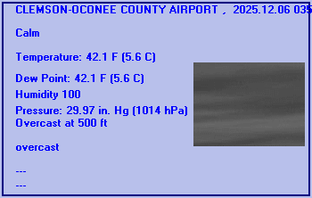
Expires:202512060900;;072176
FPUS52 KGSP 052257
ZFPGSP

Zone Forecast Product
National Weather Service Greenville-Spartanburg SC
556 PM EST Fri Dec 5 2025


SCZ104-060900-
Greater Oconee-
Including the cities of Seneca, Walhalla, Oakway, and Westminster
556 PM EST Fri Dec 5 2025

.TONIGHT...Cloudy. Patchy fog. Visibility one quarter mile or less
at times. Lows in the upper 30s. Light and variable winds.
.SATURDAY...Patchy fog in the morning. Mostly cloudy. Visibility one
quarter mile or less at times in the morning. Highs in the lower
50s. Southwest winds around 5 mph.
.SATURDAY NIGHT...Mostly clear. Patchy fog after midnight. Lows in
the lower 30s. West winds around 5 mph in the evening, becoming
light and variable.
.SUNDAY...Mostly sunny. Highs in the mid 50s. Northeast winds around
5 mph, becoming south in the afternoon.
.SUNDAY NIGHT...Mostly cloudy. A chance of rain after midnight. Lows
in the upper 30s. Light and variable winds, becoming north around
5 mph after midnight. Chance of rain 40 percent.
.MONDAY...Partly sunny with a 40 percent chance of rain. Highs in
the lower 50s.
.MONDAY NIGHT...Mostly cloudy. Lows around 30.
.TUESDAY...Partly sunny in the morning, then clearing. Highs in the
upper 40s.
.TUESDAY NIGHT...Partly cloudy. Lows in the lower 30s.
.WEDNESDAY...Mostly sunny. Highs in the mid 50s.
.WEDNESDAY NIGHT...Partly cloudy. Lows in the upper 30s.
.THURSDAY...Mostly sunny. Highs in the mid 50s.
.THURSDAY NIGHT...Partly cloudy. Lows in the upper 30s.
.FRIDAY...Sunny. Highs in the mid 50s.

$$


CLEMSON-OCONEE COUNTY AIRPORT , SC, United States (KCEU) 34-40N 082-53W 268M
Dec 05, 2025 - 08:54 PM EST / 2025.12.06 0154 UTC
Wind: Calm:0
Visibility: 10 mile(s):0
Sky conditions: overcast
Temperature: 42.1 F (5.6 C)
Dew Point: 41.0 F (5.0 C)
Relative Humidity: 95%
Pressure (altimeter): 29.99 in. Hg (1015 hPa)
ob: KCEU 060154Z AUTO 00000KT 10SM OVC008 06/05 A2999 RMK AO2 SLP158 T00560050
cycle: 2
Use the RELOAD facility on your browser to retrieve the latest data.