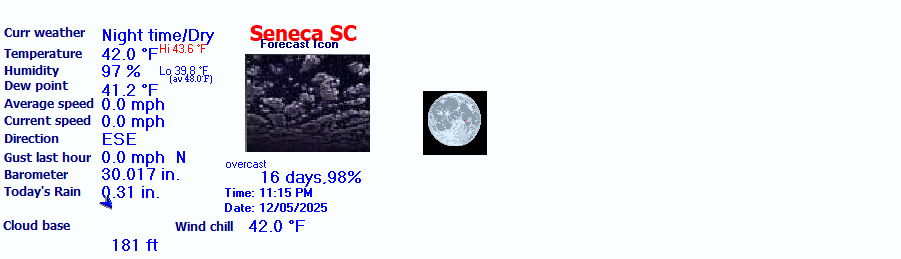

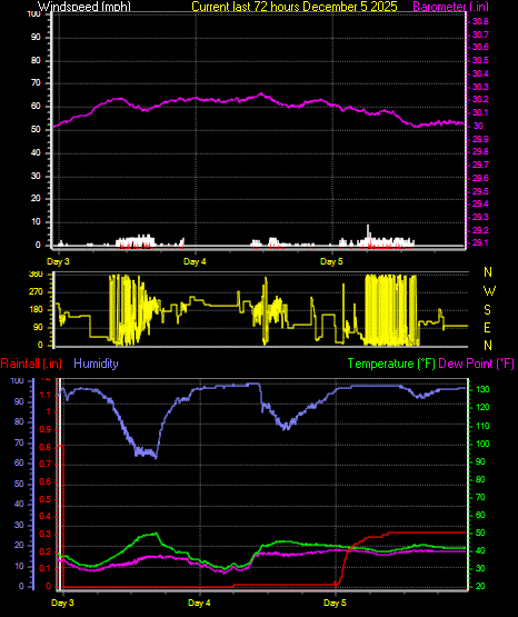
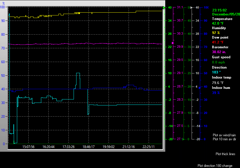
| Weather Data | |||
|---|---|---|---|
| LAST READING AT TIME: 2:55 AM DATE: June 10 2026, time of next update: 3:00 am | |||
| Current Weather | Night time/Dry | Current Temperature | 69.4°F (20.8°C), Apparent temp 74.8°F |
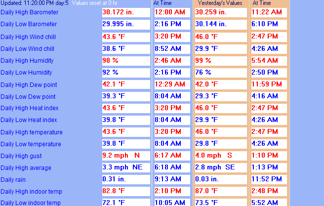
| Maximum Temperature (since midnight) | 71.8°F at: 12:11 AM | Minimum Temperature (since midnight) | 69.4°F at: 2:49 AM |
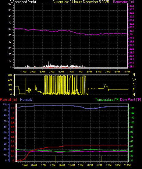
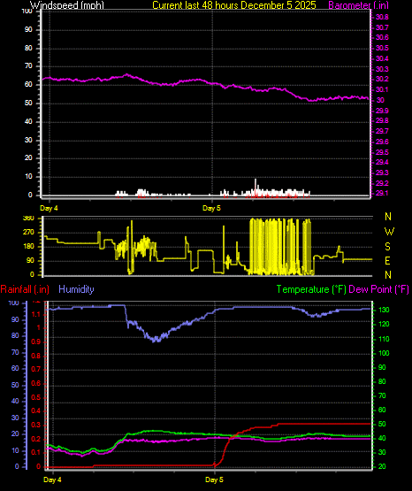
| Average windspeed (ten minute) | 0.0 mph | Wind Direction (ten minute) | SE (135°) |
| Windchill Temperature | 69.4°F | Maximum Gust (last hour) | 0.0 mph at: 2:00 AM |
| Maximum Gust (since midnight) | 0.0 mph at: 8:36 AM | Maximum 1 minute average (since midnight) | 0.0 mph at: 4:44 PM |
| Rainfall (last hour) | 0.00 in. (0.0 mm) | Rainfall (since midnight) | 0.00 in. (0.0 mm) --- |
| Rainfall This month | 0.79 in. (20.1 mm) | Rainfall To date this year | 20.11 in. (510.8 mm) |
| Maximum rain per minute (last hour) | 0.00 in/min | Maximum rain per hour (last 6 hours) | 0.00 in/hour |
| Yesterdays rainfall | 0.42 in | DewPoint | 69.1°F (Wet Bulb :69.2°F ) |
| Humidity | 99 %, Humidex 84.0°F | Barometer corrected to msl | 30.092 in. (1019.0 hPa) |
| Pressure change | +0.01 in. (last hour) | Trend (last hour) | STEADY |
| Pressure change (last 12 hours) | -0.11 in | Pressure change (last 6 hours) | -0.04 in |
| Current Indoor Temp. 82.6°F | |||
| Current Indoor Hum. 44% | |||
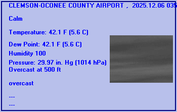
Expires:202606100800;;468343
FPUS52 KGSP 092309
ZFPGSP

Zone Forecast Product
National Weather Service Greenville-Spartanburg SC
707 PM EDT Tue Jun 9 2026


SCZ104-100800-
Greater Oconee-
Including the cities of Seneca, Walhalla, Oakway, and Westminster
707 PM EDT Tue Jun 9 2026

.TONIGHT...Mostly cloudy. A slight chance of showers and
thunderstorms this evening. Patchy fog after midnight. Lows in the
upper 60s. Light and variable winds. Chance of rain 20 percent.
.WEDNESDAY...Partly sunny. Patchy fog in the morning. A chance of
showers and thunderstorms in the afternoon. Humid with highs in the
mid 80s. Southwest winds around 5 mph. Chance of rain 50 percent.
.WEDNESDAY NIGHT...Partly cloudy. A chance of showers and
thunderstorms in the evening. lows around 70. West winds around
5 mph. Chance of rain 40 percent.
.THURSDAY...Sunny. A chance of showers and thunderstorms in the
afternoon. Humid with highs around 90. West winds around 5 mph.
Chance of rain 50 percent.
.THURSDAY NIGHT...Mostly clear. lows in the lower 70s. West winds
around 5 mph.
.FRIDAY...Sunny. Highs in the lower 90s. Heat index values up to
100.
.FRIDAY NIGHT...Partly cloudy. Lows in the lower 70s.
.SATURDAY...Mostly sunny. A chance of showers and thunderstorms in
the afternoon. Highs in the lower 90s. Chance of rain 40 percent.
.SATURDAY NIGHT...A chance of thunderstorms in the evening. Partly
cloudy. Lows in the lower 70s. Chance of precipitation 40 percent.
.SUNDAY...Mostly sunny. A chance of showers and thunderstorms in the
afternoon. Highs in the upper 80s. Chance of rain 40 percent.
.SUNDAY NIGHT...Mostly cloudy with a chance of showers and
thunderstorms. Lows around 70. Chance of rain 40 percent.
.MONDAY...Partly sunny. A chance of showers in the morning, then
showers likely with a chance of thunderstorms in the afternoon.
Highs in the mid 80s. Chance of rain 60 percent.
.MONDAY NIGHT...Mostly cloudy with a chance of thunderstorms.
Showers likely, mainly in the evening. Lows in the upper 60s. Chance
of rain 60 percent.
.TUESDAY...Mostly cloudy. A chance of showers in the morning, then
showers likely with a chance of thunderstorms in the afternoon.
Highs in the mid 80s. Chance of rain 60 percent.

$$


CLEMSON-OCONEE COUNTY AIRPORT , SC, United States (KCEU) 34-40N 082-53W 268M
Jun 10, 2026 - 01:54 AM EDT / 2026.06.10 0554 UTC
Wind: Calm:0
Visibility: 5 mile(s):0
Sky conditions: clear
Weather: mist
Temperature: 71.1 F (21.7 C)
Dew Point: 71.1 F (21.7 C)
Relative Humidity: 100%
Pressure (altimeter): 30.11 in. Hg (1019 hPa)
Pressure tendency: 0.04 inches (1.4 hPa) lower than three hours ago
ob: KCEU 100554Z AUTO 00000KT 5SM BR CLR 22/22 A3011 RMK AO2 SLP186 T02170217 10250 20217 56014
cycle: 6
Use the RELOAD facility on your browser to retrieve the latest data.